Newsletter Subscribe
Enter your email address below and subscribe to our newsletter
Enter your email address below and subscribe to our newsletter

CHICAGO (WLS) — Severe weather was in the forecast for the Chicago area Wednesday, including a risk of tornadoes that has now moved further south.
Parts of central Illinois are under a Tornado Watch Wednesday evening.
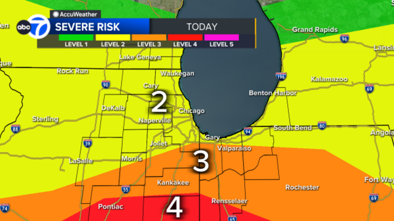
In an update late Wednesday morning, the Storm Prediction Center had areas to the south of the Chicago area under a Level 3 risk for severe weather.
Parts of Kankakee, Kendall and Will counties and northwest Indiana were under a Level 3 risk for severe weather, with the rest of the Chicago area under a Level 2 risk.
ABC7 AccuWeather meteorologists said the highest risk of severe weather will come in the mid-to-late afternoon and evening, from 2-6 p.m. the risk includes high winds up to 70 mph and a risk of isolated tornadoes. There will still be a few storms in the area from 6-10 p.m.
The entire Chicago area will be under under a Flood Watch until 9 p.m. Wednesday.
SEE ALSO: Track power outages in your area with the ABC7 Chicago Power Outage Tracker
A Ground Delay is in effect for O’Hare Airport.
Over 200 flights are canceled at O’Hare, with delays of about 90 minutes. Nearly 100 flights have been canceled at Midway airport.
SEE ALSO: Track power outages in your area with the ABC7 Chicago Power Outage Tracker
In the north suburbs, video showed trees on top of cars amid high wind gusts.
Video shows trees on cars during high winds in the Niles-Skokie area on Wednesday, June 17, 2026.
Illinois State University closed early at 2 p.m. due to the chance for severe weather.
A train was knocked off its tracks after strong storms blew through Monmouth, Illinois on Wednesday morning. It was not clear what caused the derailment, or if any injuries were reported.
A train was knocked off tracks after strong storms blow through Monmouth, Illinois on Wednesday.
According to the National Weather Service, last week’s severe weather in northern Illinois produced 17 tornadoes. That brings the total number of tornados in the state this year to 138, just four shy of the record and we’re only midway through June.
A tornado Streator was one of the most severe so far this year. NWS says it was an EF-3, and it caused widespread damage to homes and businesses in town. But it was just one of more than a dozen tornados last week. A EF-1 touched down in Bartlett and Naperville causing some property damage as well though not as severe.
“Just remarkable unprecedented stretch of frequency of severe weather and tornadoes across the state,” Illinois climatologist Trent Ford said.
Ford says Illinois is on the verge of breaking the number of tornadoes in the state for the third time in the last four years. The current record of 142 was set in 2024. Ford says historically, the state has seen an unprecedented amount of tornado activity in the last several years. For more than 70 years from 1950 until 2022, Illinois had more than 100 tornadoes in a year four times. The last four years however have each seen more than 100 tornadoes, and he expects we will break the record soon for the third time this decade.
“Part of what we’ve seen over the last four years is the right conditions of whether at the right time in a contributions of a long-term trend,” Ford said.
Meteorologists consider tornado season to generally run from April through June. But Tornadoes can develop at any time of the year. Earlier this year in March, another EF-3 tornado ripped through Kankakee and Aroma Park, one of 12 in Illinois and northwest Indiana.
The state climatologist says this has been an unprecedented time for tornadoes and climate change is likely a factor, but he says it’s a complicated equation.
“Part of it is we’ve been in these patterns of variability of our weather that make for the right conditions at the right time,” Ford said. ‘So people can think of it as luck probably bad luck.”
Ford says looking at climate models suggests this trend will continue. The environments could lead to continued years of higher tornado activity.
Many areas are still reeling from recent tornadoes as the next round of storms comes in.
The threat of more bad weather couldn’t come at a worse time. Many people are still cleaning up and recovering. And with heavy rains promised, some are wondering what’s next.
Al Mills was bracing for more storms Wednesday.
“It happened so fast; it was about five seconds,” Mill said.
He’s cleaning up from last week’s tornado damage that left his home, garage and car in shambles.
“I haven’t recovered from anything,” Mill said. “I mean, we have no power; there’s water coming in the basement from the rain. There’s been no recovery.”
It was expected to be another challenging day Wednesday for people in Merrillville, Indiana, especially with the promise of more severe weather.
It was expected to be another challenging day Wednesday for people in Merrillville, Indiana, especially with the promise of more severe weather.
It’s been nearly a week since an EF-2 tornado with winds up to 135 mph hit the northwest Indiana town, causing extensive damage to hundreds of homes and businesses. Fortunately, there were no serious injuries reported.
NIPSCO is still working to restore service to those who lost power because of the storms.
Wednesday morning, crews worked to secure the roof of a Catholic high school, while Thomas and Debra Avery tried to pump out the foot of rainwater already in their basement. Everything down there is a total loss.
“I just hope that I can keep the sump pump running where it’s not gonna flood again.,” Thomas Avery said. “I just got done getting all the water out; so I gotta keep this thing running.
And despite the challenge, the Averys, like a lot of people, are relying on their faith to keep them going.
“Just hope that everything’s OK,” Debra Avery said. “I’ve just been praying that the Lord will keep us all safe over here in our neighborhoods cause we got some awesome neighbors.”
Local officials said they are on alert too, ready to respond to any emergencies. They are encouraging residents to use their tornado recovery website to find helpful resources.
Meanwhile, the living hope church plans on offering food assistance Wednesday afternoon to those who need it.
There’s a tornado recovery website at merrillville.in.gov/tornado. It’s available for people in Merrillville with helpful resources, especially as this next round of storms blows through.
Copyright © 2026 WLS-TV. All Rights Reserved.
Source link
See more: The Global Track