Newsletter Subscribe
Enter your email address below and subscribe to our newsletter
Enter your email address below and subscribe to our newsletter

KANSAS CITY, Mo. (KCTV) – FIRST WARN WEATHER DAY Wednesday. Chance for severe weather returns quickly. Kansas City’s risk level is 2/5 with a higher 3/5, and greater chance for severe storms east of KC.
Tonight, mostly clear and quiet. Low temperatures expected in the upper 60s to start Wednesday.
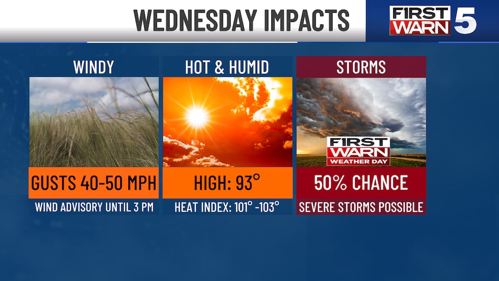
A First Warn Weather Day is in place for a significant severe weather threat.
The risk: Eastern areas are under a Level 3/5 severe weather risk, while the Kansas City metro is on the western fringe of the threat and is under a Level 2/5 risk.
When storms arrive: They could start as early as 3 pm near Kansas City, and they look to move out of our far southern and eastern counties by 8 pm.
Where they’ll hit: Storms are expected to develop along a cold front, with the I-35 corridor as a likely launching point. The Kansas City metro is on the fringe and may luck out with no storms if the front is fast enough. The odds for severe storms in KC are lower than in previous forecasts, as the storms may just be born over or near the city. Right now the KC metro is in a low probability, high impact situation.
It will take a little time for them to strengthen to severe limits, But, we are not in the clear and there’s a chance they develop earlier than expected. Regardless, quickly strengthening storms are expected for areas south and east Kansas City. Those areas will be most likely to see hail, high winds, and an isolated tornado.

To get the latest weather updates sent to your phone, download the KCTV5 Weather app here.
Windy and Hot Before the Storms: Heat and humidity will surge through the afternoon. Highs reach the low 90s with feels-like temperatures around 101 – 103 degrees. Winds will gust to 50 mph from the southwest ahead of storms, a Wind Advisory is in place.
Thursday: Relief arrives. Highs in the upper 70s with a 30% chance of morning showers.
Friday: Warmer and fantastic! Sunny skies with highs in the mid-80s.
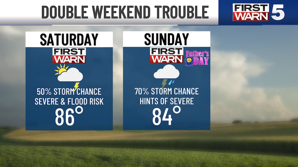
New Weekend First Warns: We have to watch Saturday’s match between Ecuador and Curaçao, as a Level 2/5 severe risk and increasing rain chances are showing up in the latest information. For now, it’s just something to keep an eye on and be aware of as the best chance for rain & storms comes Saturday night into Sunday. Sunday is Father’s Day (along with the first official day of summer), and it looks wet at times. A First Warn is in place for likely rain.
Copyright 2026 KCTV. All rights reserved.
Fonte do Artigo
See more: The Global Track